© 1995-2015
Arts Computer Technologies
Arts Computer Technologies

Travel all over the world with WorldNewsMapper
WorldNewsMapper is the only application in the world with an extensive and exciting range of processing options for
all kinds of stories. Produce your video sequences quickly and easily from images, graphics, text, and animations
embedded in a multidimensional map: with WorldNewsMapper, TV viewers and web users will travel all over the world.
all kinds of stories. Produce your video sequences quickly and easily from images, graphics, text, and animations
embedded in a multidimensional map: with WorldNewsMapper, TV viewers and web users will travel all over the world.
Bing Maps
WorldNewsMapper utilises satellite data and the 45° bird's eye images from Microsoft Bing Maps™. Only the most up to date map data are downloaded from the internet. With resolutions as high as 0.3 metres per pixel, roads and buildings can be seen in all their detail.
WorldNewsMapper utilises satellite data and the 45° bird's eye images from Microsoft Bing Maps™. Only the most up to date map data are downloaded from the internet. With resolutions as high as 0.3 metres per pixel, roads and buildings can be seen in all their detail.
Professional objects
WorldNewsMapper illustrates your story with a diverse range of objects that can be used on the underlying map. All of these objects can be animated in a variety of ways, positioned anywhere, and edited intuitively.
WorldNewsMapper illustrates your story with a diverse range of objects that can be used on the underlying map. All of these objects can be animated in a variety of ways, positioned anywhere, and edited intuitively.
Integrating political maps
WorldNewsMapper comes with a library of all national and interstate borders in the world, allowing you to integrate political information quickly and easily. You can also colour one or more countries for greater emphasis. The map colours and outlines can be adapted to your own layout ideas.
WorldNewsMapper comes with a library of all national and interstate borders in the world, allowing you to integrate political information quickly and easily. You can also colour one or more countries for greater emphasis. The map colours and outlines can be adapted to your own layout ideas.
5
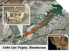
Maps down to street level Bing Maps™ are available in a resolution of 0.3 metres per pixel. At this resolution, roads and buildings can be clearly recognised. This map material is constantly updated and expanded by Microsoft©. Smooth transitions between the different map formats are possible during a flight.
Maps down to street level Bing Maps™ are available in a resolution of 0.3 metres per pixel. At this resolution, roads and buildings can be clearly recognised. This map material is constantly updated and expanded by Microsoft©. Smooth transitions between the different map formats are possible during a flight.
4
Expand your object library yourself All objects can be modified in an editor or directly at the output. For fast work, you can predefine objects and create a object library for your own needs. When editing objects, you can define parameters like the typeface, colour, and background of text or the image for an icon.
Expand your object library yourself All objects can be modified in an editor or directly at the output. For fast work, you can predefine objects and create a object library for your own needs. When editing objects, you can define parameters like the typeface, colour, and background of text or the image for an icon.
3
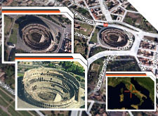
Spot on! The zoom object
A number of objects are designed specifically for working with maps, for instance the zoom object. This object can magnify and therefore highlight a section of a map. In addition, it can also be used to select a map format and present this section in the bird's eye view or as a road map.
2
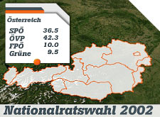
Update your object automatically
The dynamic data object supports the automation of recurrent contributions. In doing so, it retrieves information from external data sources and depicts this in graphical form. The objects current position and the associated information like country, federal state, or city function as filters for data updates.
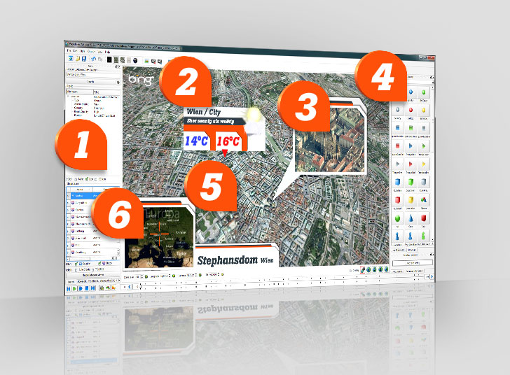
Powerful user interface with a multitude of capacities
1
Integrated Bing search functions
The integrated Bing Map™ search function lets you research places and addresses directly in the application. With a simple mouse click, transfer to your graphic the results of your Bing location search including the national and interstate borders.
Integrated Bing search functions
The integrated Bing Map™ search function lets you research places and addresses directly in the application. With a simple mouse click, transfer to your graphic the results of your Bing location search including the national and interstate borders.
6
Keeping track – the locator object The locator object always shows the camera's current position at any zoom factor. For the viewer it marks the position on a map section and locates it on the world map.
Keeping track – the locator object The locator object always shows the camera's current position at any zoom factor. For the viewer it marks the position on a map section and locates it on the world map.


features
Advanced Rendering Technologies & Solutions
